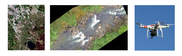
The measurement techniques to be presented and discussed aim at covering all relevant techniques within remote sensing, various air-borne devices and instruments operated on-ground, floating on the water surface or possibly below the water surface.
Geographical information systems (GIS) will be central data processing tools to present.
Register here to participate
Date: 9 January 2018
Time: 9.00 – 17.30
Place: The Norwegian Environment Agency, Brattørkaia 15, Trondheim, Norway.
(See full program below)
The purpose of the seminar is to present state-of-the-art in terms of measurement and dataprocessing techniques for the assessment of hydro-morphological conditions in regulated rivers, lakes and reservoirs.
The Norwegian hydropower system is ageing, and many hydropower plants are due for technical refurbishment and re-licensing of environmental conditions. There is currently extensive research going on throughout Europe in order to establish a classification system for hydro-morphological status and changes in rivers and lakes. The workshop will present techniques that are considered important in order to support re-licensing of hydropower concessions and classification of water-bodies, and as the basis of proposing cost-efficient measures to reach good ecological status or good ecological potential.
The seminar will be arranged as a joint effort between the research centre HydroCen, the CEDRENSusWater and the Environment Agency-HyMo projects. The seminar January 9th will be succeeded by an internal workshop January 10th with the purpose of having more in-depth discussions of the various measurement and processing techniques and their possible future applications.